
European Marine Observation and Data Network
The European Marine Observation and Data Network (EMODnet) is a consortium supported by the European Union's Integrated Maritime Policy.
The members of the consortium collaborates on marine observation, processing and harmonisation of data according to international standards and the free sharing of interoperable data layers and data products.
With the aim of ultimately collecting, developing and validating data of the EU’s marine waters, the network relies on existing national ventures and international networks, to ensure sustainable funding to optimize Member States' initiatives and to develop a decision-making process for European issues.
The project is organised around seven topics covering bathymetry, geology, biology, benthic habitats, chemistry, physics and human activities.
This « collect once and reuse » philosophy is intended to benefit all users of marine data, including policy makers, scientists, private industry and the public.
EMODnet Geology
In collaboration with the French Geological Survey (BRGM - Bureau de Recherches Géologiques et Minières), the ODYSC laboratory has been involved in the geology work package of the European EMODNet project since 2012.
This work package aims to produce thematic cartographic documents (seabed substrate, geology of the basement and quaternary deposits, geomorphology, mineral resources, etc.) and then orchestrates them for all marine regions under European jurisdiction.
The laboratory has thus contributed to the production of digital mapping data sets for France, harmonising them according to the protocols and standards established by the project.
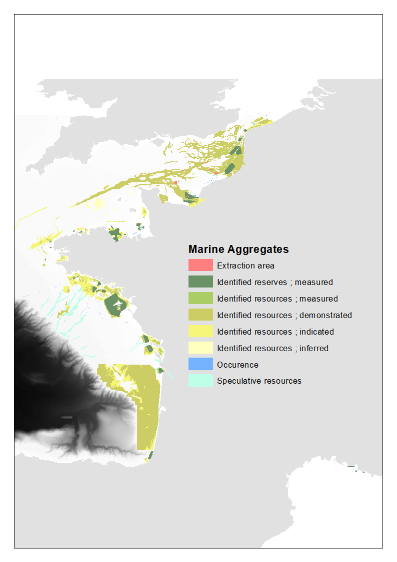
Using data held by the GEO-OCEAN research unit, distributed on an open-access basis by third-party institutes or published in scientific journals, the ODYSC laboratory has provided information on the evolution of the coastline, the nature and morphology of the seabed, recent sedimentation rates, marine aggregate resources and geological events.
The data can be accessed by clicking HERE
EMODnet Bathymetry

Through the successive EMODnet Bathymetry projects, and an ever-expanding list of partners, the highly successful EMODnet Bathymetry portal provides an overview and access to available bathymetric datasets and to harmonised digital bathymetry (DTM) for the seas of Europe.
The EMODnet consortium currently involves a number of hydrographic services, research institutes, authorities, and private companies.
The French Hydrographic service is project administrator.
Ifremer is widely involved with the GEO-OCEAN research unit processing and compiling data, Sismer as the data center for the French oceanographic fleet and software development groups for bathymetry data processing (Globe, seanoe.org/data/00592/70460/) and dedicated Web services.
The latest EMODnet Digital Terrain Model (DTM) for European Seas was released in December 2020. This bathymetry product offers excellent resolution, a powerful 3D-visualisation functionality, and full coverage of Europe’s seas. It is available free of charge for viewing and downloading, and sharing by OGC web services from the EMODnet Bathymetry portal.